Actually, just UARS (Upper Atmosphere Research Satellite). But NASA is predicting only 1 in 3200 chance that a part of it will hit a person. With an orbital inclination of 57 degrees, UARS will reenter and parts of it will strike somewhere between 57 deg north latitude and 57 deg south latitude. Which covers most of the inhabited surface of Earth...but there's a lot of ocean in that zone as well.
Launched on 09/12/1991, it was designed to study Earth's atmosphere, particularly the ozone layer. The original mission life was 3 years, and finally decommissioned in 2005 with a de-orbit burn (using up all of its fuel) in December '05. Since then, it has been slowly spiraling down and latest estimates put reentry happening on September 23, 2011...plus/minus a day. Dear reader, (if any), may back check facts here and here.
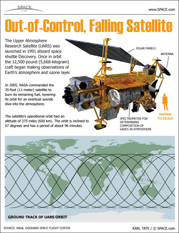
Source: SPACE.com: All about our solar system, outer space and exploration
NASA's ORSAT Orbital debris projection: (pay attention to the parts with a Demise Altitude of 0 km).

Wait for it....now, the Orbiter angle.
A fellow Orbinaut was smart enough to post simulation scenarios for UARS in this thread at O-F. Note that the scenario was created with and intended for ver 2010P1 of Orbiter. I downloaded and ran this just for grins and giggles. My simulation run predicts that Australia (somewhere SW of Brisbane) will get hammered with the debris...again! I say again, because another piece of US space hardware, Skylab, managed to shower the Aussies with pieces of itself back in July of 1979. Apparently, the Shire of Esperance fined the United States $400 for littering, a fine which remained unpaid for 30 years.
Here is a screen shot of my sim run (click on image to enlarge):

And a screen shot from Google Earth (click on image to enlarge):

Or visit my web site to download the *.kmz file (UARS Demise) and open that file with Google Earth.
How's this for synchronicity?
The first time I started the scenario with Orbiter, my mp3 play list within Orbiter started playing "Re-Entry" from In the Shadow of the Moon soundtrack.
Rather fitting, and spooky at the same time.
No comments:
Post a Comment